
PDF chapter test TRY NOW
Latitudes and Longitudes
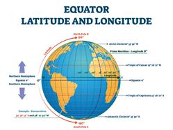
- Latitudes and Longitudes are horizontal and vertical imaginary lines drawn on the Globe to find the location and calculate distance and time.
- Ptolemy – First person to draw the lines of latitude and longitude on a map.
- ‘Geographia’ a book by Ptolemy
Latitudes
- Imaginary lines
- Runs horizontally on East - West direction on the Earth
- They are called the lines or parallels of latitudes.
- They are also called parallels, as they are parallel to the equators and never meet.
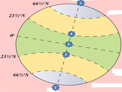
- The 0° line of latitude which divides the Earth into two halves is known as the Equator.
- These halves are known as Northern and Southern Hemisphere.
- From the Equator, parallel lines are drawn towards the North and South poles at equal intervals.
Important!
The latitudinal extent: \(1°\) line of latitude \(=\)\(111\)\(km\).
From the Equator toward North and South poles the length of the lines of latitudes decreases because is Geoid in shape.
- The \(90°\) North and \(90°\) South (Poles) are not lines, they are found as points.
- Northern latitudes – Lines of latitudes between the Equator and North Pole.
- Southern latitudes – Lines of latitudes between the Equator and South Pole.
Total number of Northern latitudes (parallels in northern hemisphere) \(= 89\)
Total number of Southern latitudes (parallels in southern hemisphere) \(= 89\)
Equator \(= 1\)
At poles (as points) \(= 2\)
Total number of parallels found on earth \(= 181\) parallels
The Equator is the longest of all lines of latitude. Hence, it is also known as ‘The Great Circle’.
 Register for free to see more content